Saturday, November 20, 2010

Grand Canyon -- Day 3

27 September -- The Roaring Twenties

Today was a day of Kayak Carnage!
We started at the 18.5 mile ledges, a great camp site with entertaining interplay of the moonlight playing on the cliffs above. Floating through the boulder narrows was interesting, seeing the > 40 year-old driftwood at the top of the large rock gave me a respect for the amount of water that flowed here when the river was wild.
From Grand Canyon Day 3

First on the agenda of the day was North Canyon Rapid. We got backed up behind the private group from Oregon and a commercial trip so we had to wait our turn. It was a fun run with a nice long wave train. The camp in the eddy below would be a really nice spot. Next was 21 Mile, my log says I can't remember...must not have been notable. Indian Dick Rapid (23 -), well marked by the phallic pinnacle on river right, had pour-overs left and right with large lateral waves. 23.5 - rapid, my notes say run the right channel. We ended up not scouting 24-mile rapid, bigger than expected, Michael flipped and rolled back up.
From Grand Canyon Day 3

We stopped for lunch at 24.5-mile r. Dan caught a trout here. We scouted the rapid and were awed by how tight and sharp the turn is. While setting up to run I watched Tim ride the crest of the guard wave above the big hole at the base of the rapid. He seemed like he was on the skyline for a long time. Everyone got through this just fine. In short order we were at 25-mile rapid, big waves, hole in this rapid was pretty easy to miss. Big Eddy below, it took me three tries to break free and get back into current.

Since we are now in the Redwall Limestone, caves, alcoves, and springs are starting to appear. Some larger cave were explored by some of the Kayakers on river left at 26 0r 26.5 mile. Tiger Wash Rapid (27 mile)was straight forward at the beginning, with huge waves, but the hydraulics below on river right are tremendous. I had a tube of the raft sucked almost under, and tried to wave the kayakers behind to go left, but it was too late. Dan M., Erin, and David all had long scary swims. It took awhile to sort out all the boats, boaters, and paddles.
From Grand Canyon Day 3

29-mile rapid was easy. We camped at Shinumo Wash, a large camp with the kitchen area on a ledge of sand just below a cliff of Redwall Limestone. While writing in my journal a golf-ball sized chunk of limestone bounced off of an un-occupied chair next to Sam, and hit my headlamp and head, knocking off my glasses, and kind of surprising me! Initially I had though that Sam had tossed a rock at me to look at without warning, but then after recovering from our shock we figured out what had happened. It was a good thing that the chair had been unoccupied!

Time and distance are starting to make our exchange at Phantom Ranch look tight.


Friday, November 19, 2010

Grand Canyon -- Day 2, House Rock Rapid

September 26

Jackass Camp to 18-1/2 mile ledges.

Soap Creek Rapid was a little more challenging, yet there was no excitement (carnage) here. We stopped for lunch just above Shearwall Rapid on ledges of the Supai Group. There were shadowed overhangs, clear deep water for swimming, and lots of trout. Scott caught three and some of the rest of us had a lot of sport. We all kept cool in the water and shade. The kayakers started the seal-launch tradition. The canyon here was deep, and required lots of active rowing and paddling all day; it was little tiring with the hot weather.

Near the end of the day we arrived at House Rock Rapid, the first of the "big" rapids. We had all understood that this rapid of all, would be most difficult at the lower water that we had at the steady 8Kcfs discharge from the Glen Canyon Dam. Once we saw the rapid, we all understood what the difficulty was about. All the water was getting shoved by the debris fan on river right into a curving and broken rock-fall and cliff on the left. Guidebooks and advice from professional guides were not helpful, some said "scout right" some said "scout left" however, all emphasized moving from left to right to break through the lateral waves on the right to avoid getting shoved into the ledge hole and then the second hole on the left in the bend. That was all well and good, but the right side was really bony, with lots of rocks at this water level. These rafts were loaded more heavy than any thing I had ever tried to maneuver in any moving water.

The suggested strategy for us neophyte oarsmen was to start on the left side of the tongue and to row or pull (facing upstream)in a down stream ferry (meaning crossing the current at an angle) to hit the laterals below the worst of the shallow rocks, and then spin to face the holes head on, which we were going to inevitably go through. That was the plan, I had my landmarks selected, and committed the plan to my head. So the kayakers went, with not much problem; Michael and Tim as the probes did fine, Jim paddled through fine, but flipped and swam in the tailwaves, Erin did a 360 but stayed upright in the hole, Dan flipped but pulled off a roll. I followed Sam, I didn't see his run. I started in on the line that I had picked. However, everything accelerated. Suddenly I knew that I was not making the ferry, nor was I going to be able to spin the boat to face the hole, so I did my best to line up on the hole backwards...I think that I did okay, but as soon as I hit that hole the raft stopped, tilted upstream and spun counterclockwise all in one sharp movement. Before you read that last sentence I was ejected (according to eyewitnesses I did a great forward flip) almost taking the left oar with me, I tried to grab the lifelines and missed but grabbed the blade of the right oar as I hit the water, and so hung on to the raft through the two holes. Once out of the worst of the rapid I tried to climb back in the raft and couldn't; after some moments of frantic effort, Michael appeared with his kayak and lent his bow as a platform to to allow me to re-board. After watching Sam and I try the recommended maneuver, Dan Solie and Max opted for taking the whole thing on straight away, and made it through without any further drama. Dan M. and Andy have excellent accounts of the House Rock "experience(carnage)". House Rock was a humbling experience, knowing full well that there were at least 10 more rapids with this difficulty or grater, and lots of miles to row, I hoped that I had learned something.

We camped at 18-1/2 mile ledges in a busy eddy with a line that is hard to make in a heavy raft, if you plan to camp here, be prepared to hit the eddy line high. There is an interesting interplay between the cool downstream breeze and the warm side-canyon wind; one moment you are chilly and putting on clothes the next you are HOT!. Very nice camp.

Monday, November 1, 2010

Grand Canyon -- Day 1

25 September -- Lee's Ferry to Jackass Camp

12:00 noon start, kind of like a normal Alaska river trip, at the "crack o' noon". But we've got lots of excuses. The ranger briefing show was delayed because of the other private group that was launching, one of their party left their ID at the South Rim. I'm really glad that our trip leaders Andy and Wendy kept reminding us: "Do you have your ID?". Two most important parts of this trip: PFD, forget the food, camera, clothes or anything else just remember your ID&PFD (at least the PFD has real world consequences; if you are not wearing you will sink in the river). The water here is cold, it comes out of the bottom of the spillway Glen Canyon Dam at a less than refreshing 50 degrees F.

Finally we were rigged, and we started down the river, 4 rafts, 6 kayaks, one inflatable canoe and one inflatable kayak and 15 souls. We floated our way down into the Kaibab Limestone, descending into the Permian age.
Click on photo to enlargeFrom Grand Canyon Day 1
We lunched at 2 mile (number of river miles below Lee's Ferry), just above Cathedral Wash. Lots of locals were fishing the banks along the first mile or so.
Click on photo to enlargeFrom Grand Canyon Day 1

After floating under the Navajo Bridge we crossed the base of the Kaibab Limestone and floated down into the Coconino Sandstone, a red cliff and slope formation ; the upper part was planar bedded with thin beds or red sandstone alternating with shale, perhaps laid by a river near the Permian coast. There were also lenses and beds of thicker cross-bedded sandstone that appear to be fossilized sand dunes.
Click on photo to enlargeFrom Grand Canyon Day 1

Badger Rapid culminated our day. Pretty much a straight forward read and run with a rock/hole/pourover on right-center and boulder garden on left. Ran tongue favoring right and downstream ferry right to meet lateral waves head on. Tail waves were surprising. (In retrospect...I give my rowing abilities too much credit here, the river has much in store for us!)

Friday, October 29, 2010

Grand Canyon -- Day 0

Rigging Day -- Flagstaff to Lee's Ferry

The "Reynolds" trip crew woke early, and were treated to a great breakfast of "Egg McMichael" sandwiches while packing and repacking our dry bags and organizing our gear which was collecting in what seemed like an impossibly large pile outside of the River House. How would all this stuff fit in four rafts? Marilyn picked the 15 of us up in the Moenkopimobile and drove us to Lee's Ferry, We tried to keep everyone on the bus so that we didn't have to count and recount to make sure that we weren't leaving anyone behind. It was a hot trip, filled with anticipation for getting on the river.
Click on a photo to see a larger versionFrom Grand Canyon Day 0
For me, the geologic field trip had already started the day before on the Arizona Shuttle ride from Phoenix where we went up and over the Mogollon Rim and up on to the Colorado Plateau. The field trip continued on the outskirts of Flagstaff where we could clearly see the forested volcanic landforms of the geologically young San Fransisco Volcanic Field. As we neared the Little Colorado we could look to the west and see the Moenkopi Escarpment, a monocline (single sided fold or step in otherwise horizontal rocks).
Click on a photo to see a larger versionFrom Grand Canyon Day 0
After crossing the Little 
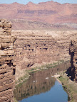
Colorado, which was bank full and running muddy from the recent rains we could see the Echo Cliffs to the east, which are capped by the Navajo Sandstone the youngest layered rocks that we will see on this trip until we float the length of the canyon and pass the Grand Wash Cliffs. The Echo cliffs mirror the Vermillion Cliffs on the North side of the Colorado River and dominate the panoramic view in the area of the Navajo Bridge and Lee's Ferry.

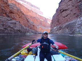
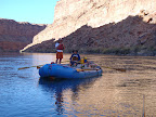
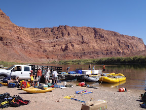
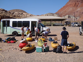
Upon arrival at the Lee's ferry rigging site we disembarked into a scene of chaos and confusion as Moenkopi Riverworks was trying to launch another group as well as ours, our boats were partially rigged, but there was still much to load and rig. Rico, Marilyn and the rest of the Moenkopi crew did an amazing job of answering questions, giving advice, and dividing up the gear between the 32 trip participants and the flat-bed truck of gear and boats. I ended up with the 18-foot Avon, which would become my home and steed for the next three weeks I have a soft place in my heart for her still.
Click on a photo to see a larger versionFrom Grand Canyon Day 0
As a boatman, I soon learned that one of my responsibilities was to know what was loaded on the Avon and where it was stowed,. Although it changed a little from day to day this is what the Avon and I carried for the next three weeks:
  • Bow frame hatch: camp stove, 20 lb propane bottle, expedition water filter, two rocket boxes of food (days 7-8) . The boxes of food were converted to rocket boxes of garbage and recyclables as the food was consumed, so by the 8th day my poor Avon had become the garbage scow.
  • Ice chest: ( the seat for the rower) 4 yellow squash, a dozen or so zucchini, several heads each of romaine and iceberg lettuce, some spring mix greens, 4 bunches of celery, dozens of tomatoes and avocados, and a block of ice large enough that there was still some left 20 days later.
  • Bread Box: (aluminum dry box at the left side of the rower's feet) 4 loaves multigrain bread, 12 packages pita bread, 6 loaves french bread, 2 boxes of Kashi cereal, 2 packages of nut clusters, 3 dozen bagels, 3 dozen english muffins...maybe more.
  • Pot box: (aluminum dry box at the right side of the rowers feet) 18 plates, 18 bowls, 18 tumblers, several large mixing bowls, three large stock pots, some fry pans.
  • Stern frame hatch: (forms the bench seat for the raft passengers) Rocket boxes for days 1-6.
  • Under the bow gear net: several cases of canned soda, three large personal dry bags, an outfitter wing tarp, two folding beach chairs.
  • Lashed down on top of the bow hatch, one large personal dry bag, a large dry bage with half of the tents, a wing, a couple day dry bags, four of the infamous Paco pads, a spare PFD.
  • Lashed down on the side decks: ammo boxes that contain first aid kit, a boat repair kit, and 4 separate personal kits. A Pelican case with a s phone, and a net bag with extra straps, spare oar towers, a sand stake, a rubber mallet and a PVC pipe for the boat umbrella.
  • Lashed down on the stern frame hatch: a large aluminum kitchen table with slots so that it could double as a long spine board and a really sad water logged paco pad.
  • In a drop bag in the stern: three to four folding soccer mom chairs, some treking poles and occasionally a folding cot.
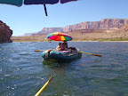
  • Lashed down elsewhere: two five gallon water jugs, two 5 gallon buckets ( mine were used as urinals in camp how lucky is that!), a large beach umbrella (that liked to launch in a gusts), various personal water bottles, and a waterproof map case that I kept on top of the pot box so that I could navigate as we floated down the river.
  • Also lashed down around the boat were as many as two kayaks, the deflated inflatable kayak (duckie) and inflatable canoe (Grabner), and a bundle of spare paddles.
  • Lashed each side were spare oars, they were kept easy to access.
If all this stuff were in a pile on the beach, it would be hard to believe that it all fit in the raft. Except for the bread box, ice chest, repair kit, strap bag, and oars all of the stuff gets unloaded every night and reloaded every morning. It's all part of the rhythm of the river.

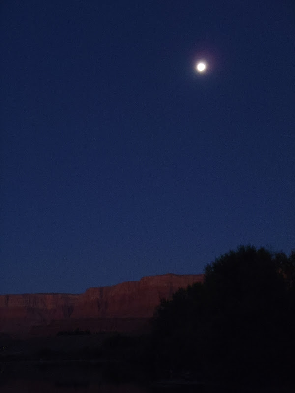
After moving 100 yards down the river to the boaters camp ( I forgot and left my PFD at the rigging beach, then sheepishly recovered it) that was the last time that I would do that on the trip. Then we had dinner and a second pre-trip group meeting at the Marble Canyon Lodge.

I slept on the boat that night after reading some John Wesley Powell under a nearly full moon. I was restless with the anticipation for what was to come in the following days...
From Grand Canyon Day 0

Sunday, October 24, 2010

Grand Canyon (Day 14?)

8 October,

River level continuing to drop, but counter-intuitively is it getting muddier?!

Doris, One Hundred Thirty-Eight and a half, and Fishtail rapids all fairly straightforward. Favor the debris fan side of the of the tongue a smoother, dryer run. Lots of morning shade, chilly, we wanted to miss waves to stay dry and warm. We had one kayaker swim in Doris. Group stopped at Kanab Creek for leg stretch and bio break. There was lots of fresh sticky, slimy mud; probably from recent flash floods. River current is fast, maybe making 10 mph?

We stopped for lunch and hike at spot below Matkatambia Canyon. A commercial trip was in the pull-in at MatKat Creek mouth leaving no room for us. Had a nice but challenging spot for lunch and hike start on little ledge just below MatKat Creek. The other private group stopped at our pull-in and tried to hike over us...they were rude in how they walked over the top of our gear and over the top of one of our crew who was feeling very poorly at the time...they ended up not being able to negotiate the cliff and traverse to the canyon. Our group went fairly far up the canyon, Michael took some great photos with my camera. We re-launched at 4:20. A commercial trip was camped at Mat Kat Hotel.

We ended up getting to Upset Rapid at 5:00. Yeesch!!! What a rapid! The big hole(s) were 2/3 of the way down the rapid, each were about 1/2 the river wide. Rocks on the right occupied most of the right side and current across the fan and rocks pushed into the holes. Enormous laterals guarded the the cliff wall on the left. Tyler hit this wall with enough force to break his spare oar in 2009, there was no way in the conditions we had to do that! Michael ran with me in the raft, I tried really hard to punch the first left lateral wave, but surfed back into the tongue, I tried to push into the second left lateral, but had lost too much momentum. So I tried to square up and add down stream power for the inevitable. We hit both holes, clawed to stay straight and moving downstream. The video shows how wet we got and how close we were to making "Upset" literally true to it's name. In the end we easily made the second eddy on the right. The self bailer was not dry until we made the eddy; there was a lot of water in the boat! Everyone else survived the run as well, bit none of the runs were "text-book examples".

Below Upset on the right is a possible camp, there was clear water in pools in the side creek, plenty of room for tents, but active rocky eddy and lots of rapid noise. Tim found a duckie paddle lodged in the rocks in the eddy below the rapid. It turned out to be from the other private group that had proceeded us by just a little bit.

We ended up at Upset Hotel camp for the night. The 2nd pull-in was the better spot, a bit of a climb up the bank, but a really cool ledge camp, with an over hanging cliff of Redwall Limestone and a narrow crack of sky for star gazing. Great acoustics off the canyon wall for a resonating morning call for breakfast!

Monday, March 15, 2010

Dalton Highway Hunting Restrictions

I shouldn't be sharing hunting secrets, but it is a fallacy that the existing Dalton Highway buffer is an artificial restriction on access. ANY Alaskan with some gumption and wits can cross the corridor and harvest caribou with a rifle and successfully transport the meat home for consumption without a snow machine. In fact most of the people I know that harvest caribou do so without the aid of off road vehicles (ORV) on the north side of the Brooks Range through creative use of skis/snowshoes and sledges or non-motorized boats. When I have traveled the Dalton Highway to the starting point of my hunt I have seen large numbers of bow hunters along the road hunting within the corridor.

The other caribou herds located along highway corridors and have ORV access (eg. Nelchina, Delta, Fortymile) are in annual crisis and under intensive Alaska Department of Fish and Game management at great expense to the state treasury. Registration and drawing hunts are par for the course, emergency closures are annual events. Predator control is a constant battle. Please keep good old Alaskan ingenuity and muscle powered access as the main and successful method of guaranteeing that the Central Arctic Caribou herd is managed for abundance and not crisis.

I have actively hunted the Central Arctic Caribou herd using non motorized access since 2005 when I realized how easy it is to access this herd outside of the 5-mile corridor. I and my family have relied on the high quality of the meat we have obtained on these hunts. The hunts have provided my sons and I some of the best quality time that we have had together since they have become adults. Part of the quality is derived is from the remoteness and the physical effort that is required by the minimal short 5 mile mile buffer before we can hunt with a rifle. This opportunity should be preserved for all Alaskans.

Here's to Senator Mike Kelly's Alaska HB 267 going down in flames!